Inscription
Side A:
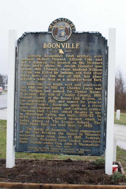
Historic Boonville's first settlers were pioneer Mother Hannah Allison Cole and her 9 children who located on the Missouri River bluffs where St. Joseph Hospital now stands, 1810. Hannah, whose husband William T. Cole was killed by Indians, ran first river ferry here. In the War of 1812, her place served a wide area as a neigborhood fort.
Boonville, on trails west and southwest, was laid out in 1817 by Charles Lucas and Asa Morgan and named for Daniel Boone. It became the seat of Cooper County, 1819. Second county in the Boons Lick Region, it was organized, 1818, and named for pioneer Sarshall Cooper. Boonville grew as a river port, distribution point, and cultural center. Thespian Hall (Lyric), oldest theater in use in Mississippi Valley, was built, 1855-57. In 1844, a boarding school opened which is today known as The Kemper School. The first State Fair was held here in 1853.
The Battle of Boonville, first engagement of the War Between the States in Missouri, occurred near town, June 17, 1861. Federals under Gen. Nathaniel Lyon routed untrained State Guards under Gen. John S. Marmaduke.
(See other side)
Side B:
(Continued from other side)
Boonville, in an upland prairie county of grain and livestock farming, is in territory ceded by Osage tribes. Settlers form the South were later joined by many from Germany. By early 1900's the M.K.T. and Mo. Pac. railroads supplanted river trade. The railroad bridge at Boonville was built in 1874 and the highway bridge in 1924.
Points of interest are the town's historic markers; Harley City Park; Christ Episcopal Church (1846); Walnut Grove Cemetery. Mo. Training School for Boys dates from 1889. Atop an Indian mound near mouth of the Lamine, in Cooper County, is grave of fur trader, first Mo. Lt. Gov. William H. Ashley. South is Chouteau Springs, part of the land given Pierre Chouteau by the Osage, 1792. At Rocky Cut, near Otterville, the James and Younger Boys robbed a train, July 7, 1876.
Here was born William M. Williams, Mo. Supreme Court Justice; Lon V. Stephens, Gov. of Mo., 1897-1901; Walter Williams, journalist, educator. Here lived David Barton, first Mo. U.S. Senator; Jacob F. Gmelich, Lt. Gov., 1909-13; George G. Vest, lawyer, statesman; George C. Bingham, Mo. artist; C. C. Bell, horticulturist.
Details
| HM Number | HMUZV |
|---|---|
| Tags | |
| Year Placed | 1959 |
| Placed By | State Historical Society of Missouri and State Highway Commission |
| Marker Condition | No reports yet |
| Date Added | Monday, October 6th, 2014 at 4:36pm PDT -07:00 |

Locationbig map
| UTM (WGS84 Datum) | 15S E 524379 N 4312153 |
|---|---|
| Decimal Degrees | 38.95800000, -92.71861667 |
| Degrees and Decimal Minutes | N 38° 57.48', W 92° 43.117' |
| Degrees, Minutes and Seconds | 38° 57' 28.80" N, 92° 43' 7.02" W |
| Driving Directions | Google Maps |
| Area Code(s) | 660, 816 |
| Closest Postal Address | At or near 18017 Jefferson Rd, Boonville MO 65233, US |
| Alternative Maps | Google Maps, MapQuest, Bing Maps, Yahoo Maps, MSR Maps, OpenCycleMap, MyTopo Maps, OpenStreetMap |
Is this marker missing? Are the coordinates wrong? Do you have additional information that you would like to share with us? If so, check in.
Nearby Markersshow on map
Maintenance Issues
- Is this marker part of a series?
- What historical period does the marker represent?
- What historical place does the marker represent?
- What type of marker is it?
- What class is the marker?
- What style is the marker?
- Does the marker have a number?
- This marker could use another picture or two.
- Can this marker be seen from the road?
- Is the marker in the median?
Comments 0 comments