Inscription
Phoenix, one of the many mill towns of the 1800s in Baltimore County, survives today as a secluded little village beside the Gunpowder River and the Northern Central Railroad 15 miles north of Baltimore. Today's Phoenix, with its big Victorian houses with their characteristic gingerbread trim, developed in the 1890s as a suburb of Phoenix Mill and its company located a half mile to its north.
The first industry at what eventually became Phoenix, was a gristmill started in 1793 by Elijah Merryman and known as "Gunpowder Mills". A saw mill and a woolen mill soon followed. In 1848, Baltimore mill owner Thomas H. Fulton founded Phoenix Cotton Mill. When he died shortly after 1851, the property was sold at public auction. The auction notice listed a "factory house" 100 by 36 feet with an iron water wheel, a stone dam with 9 feet of waterfall, plus a town with 21 brick and log houses, a store, and a 2-story house. The property sold for $28,550. For the next few years the mill had a variety of owners. In 1875, the property was obtained by the Garrett family, noted Baltimore investment bankers. With improvements including a 54 inch turbine wheel and a 175 HP reserve steam engine, the mill was placed back in production in 1881. At this time the mill town had grown to 68 dwellings, the worker force numbered over 200, and 6,000 spindles were being used to manufacture twill and sheeting goods.
In 1903, the U.S. Cotton Duck Corporation, which now owned the mill, ceased its operations at Phoenix to take advantage of lower manufacturing costs in Alabama. By 1911, the town was nearly deserted as the area was expected to be flooded by the expansion of the Loch Raven Reservoir project. The final design of the Loch Raven high dam brought back the waters of the reservoir to the very walls of the mill. In 1922, Baltimore City obtained Phoenix, along with Warren Mill further downstream, for $1,000,000. Warren Mill was drowned by the reservoir expansion and Phoenix, with its 4-story mill of Beaver Dam marble, was demolished.
Today only a roadside pond, the remains of the millraces, some fragments of a rail spur, and a few stone foundations mark the location of the once prosperous cotton duck industry that created the original village of Phoenix.
The Baltimore County Union, Dec. 13, 1873
"Phoenix is a cotton manufacturing town of considerable importance on the Northern Central Railway .... containing a population of 350. Its commercial interests consist of a very extensive cotton mill recently erected to take the lace of an old one of less capacity. Also included in the town are 30 of the best and most convenient dwelling houses for the use of the operatives".
Details
| HM Number | HMZYE |
|---|---|
| Tags | |
| Historical Period | 19th Century, 20th Century |
| Historical Place | Mill, Business Center |
| Marker Type | Historic District |
| Marker Class | Historical Marker |
| Marker Style | Free Standing |
| Placed By | Maryland Department of Natural Resources, Maryland State Highway Administration |
| Marker Condition | No reports yet |
| Date Added | Friday, September 12th, 2014 at 10:27am PDT -07:00 |
Pictures
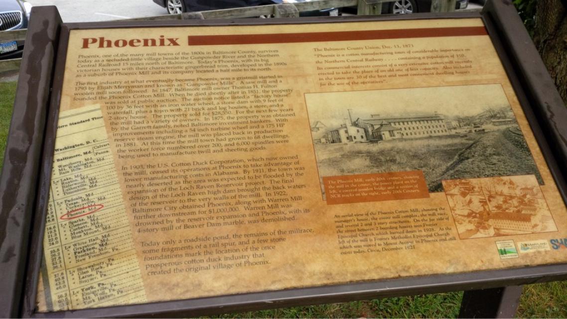

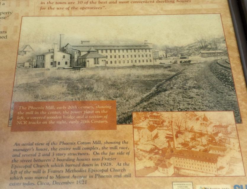
Photo Credits: [1] SEPTEMBERSPARROW1666 [2] SEPTEMBERSPARROW1666
Locationbig map
| UTM (WGS84 Datum) | 18S E 360791 N 4375654 |
|---|---|
| Decimal Degrees | 39.51926667, -76.61950000 |
| Degrees and Decimal Minutes | N 39° 31.156', W 76° 37.17' |
| Degrees, Minutes and Seconds | 39° 31' 9.3600" N, 76° 37' 10.2000" W |
| Driving Directions | Google Maps |
| Area Code(s) | 202, 410 |
| Can be seen from road? | No |
| Is marker in the median? | No |
| Closest Postal Address | At or near Torrey C. Brown Rail Trail, Phoenix MD 21131, US |
| Alternative Maps | Google Maps, MapQuest, Bing Maps, Yahoo Maps, MSR Maps, OpenCycleMap, MyTopo Maps, OpenStreetMap |
Is this marker missing? Are the coordinates wrong? Do you have additional information that you would like to share with us? If so, check in.
Maintenance Issues
- Is this marker part of a series?
- Which side of the road is the marker located?
Comments 0 comments