Inscription
On June 10, 1894, at 9:30 P.M., Edward William Jos? was mortally wounded by his new freight driver, Frank G. Eddinger, who had robbed the freight wagon the day before on Browns' Mountain. Walter Baker, Mart Van Matre and Jos? were sitting on the front porch of the Baker and Paulsen Store when Eddinger crossed the bridge. Jos? confronted Eddinger in the street. Eddinger fired hitting Jos? in the stomach, the bullet lodging against his spine. Van Matre fired five times missing Eddinger as he ran up the street. A massive north state manhunt began. Jos? died on the twelfth and was buried by the Native Sons the following day. Jos? left a wife, Mollie Dockery and five children, Eddinger was found just after dark on June 15, where Balls Ferry Road crosses the railroad tracks near Cottonwood. He exchanged fire with Constable Pleisch and Deputy Chase. Chase shot him through the chest, killing him instantly. The good people of Cottonwood refused his burial. Eddinger was taken to Redding and buried in Potter's Field.
Details
| HM Number | HM122L |
|---|---|
| Series | This marker is part of the E Clampus Vitus series, and the Native Sons/Daughters of the Golden West series. |
| Tags | |
| Year Placed | 2010 |
| Placed By | Natives Sons of the Golden West, Mt. Bally Parlor #87 and E Clampus Vitus, Trintariaus Chapter #62 |
| Marker Condition | 0 out of 10 (1 reports) |
| Date Added | Monday, October 6th, 2014 at 10:02am PDT -07:00 |
Pictures
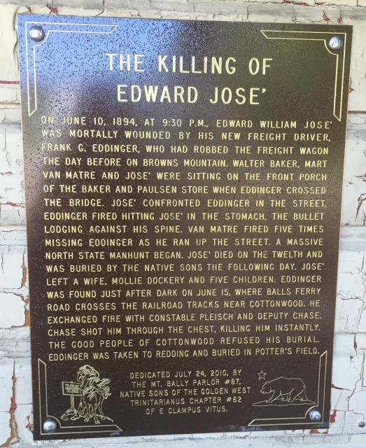
Photo Credits: [1] BELLARIDGE
Locationbig map
| UTM (WGS84 Datum) | 10T E 516341 N 4506300 |
|---|---|
| Decimal Degrees | 40.70745000, -122.80655000 |
| Degrees and Decimal Minutes | N 40° 42.447', W 122° 48.393' |
| Degrees, Minutes and Seconds | 40° 42' 26.82" N, 122° 48' 23.58" W |
| Driving Directions | Google Maps |
| Area Code(s) | 530 |
| Closest Postal Address | At or near 3 Deadwood Rd, Lewiston CA 96052, US |
| Alternative Maps | Google Maps, MapQuest, Bing Maps, Yahoo Maps, MSR Maps, OpenCycleMap, MyTopo Maps, OpenStreetMap |
Is this marker missing? Are the coordinates wrong? Do you have additional information that you would like to share with us? If so, check in.
Nearby Markersshow on map
Show me all markers in: Lewiston, CA | Trinity County | 96052 | California | United States of America
I Saw The Marker
The marker is on the front of the The Country Peddler, an antique store. However, the store is only open on Friday and Saturday and some holidays.
Jul 14, 2016 at 7:07pm PDT by bellaridge
Comments 1 comments
Maintenance Issues
- What historical period does the marker represent?
- What historical place does the marker represent?
- What type of marker is it?
- What class is the marker?
- What style is the marker?
- Does the marker have a number?
- This marker could use another picture or two.
- Can this marker be seen from the road?
- Is the marker in the median?
The title and inscription, as presented here, needs correction. The man's name is Edward Jose, with an 'e', and not "Jos", as confirmed by the photo. Incidentally, the surname is pronounced "joze", which is Welsh in origin, and not "ho-zay." It is unclear why the apostrophe is present, as seen in the picture. Also, the occupying business recently closed, but the plaque is out-of-doors and fully accessible to the public at all hours.