Bank of Leiper's Fork
The Bank of Leiper's Fork was organized in 1911 with a capital stock of $10,000. Bank officials included President Bennett Hunter, Vice President P.O. Hassell and Cashier W.L. Pinkerton. Board members in 1932 included M.A. Meacham, J.C. Green, J.W. Sullivan, John Locke, H.L. Green, H.M. Cotton, G.A. Gore, and W.H. Bizwell. The bank closed on November 26, 1932 due to unprofitable returns, without loss to depositors or stockholders. The brick bank building burned in 1992 previously housing the cabinet shop of Ben Wilkes, stores owned by Gus Carl, J.T. Kelley and Carl McMillan and service stations operated by Fulton Stutts, Fred Conner, Herbert Furlough, Raymond Earl Howell, Albert Lee Ford, George "Buster" Pewitt and Ricky Binkley.
(side 2)
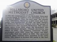
Hillsboro United Methodist Church
In 1910 the congregation of the Methodist Episcopal Church South of Leiper's Fork purchased a lot for the sum of $500. Over the next year, the current brick sanctuary, featuring a bell tower and front gable, was constructed. In 1939, the name changed to Hillsboro Methodist Church with the merger of the northern and southern Methodists. The current name dates from 1968 when the Methodists and United Brethren merged. Though electricity was added in 1942, the building remained largely unchanged until 1962 when the annex was built. Fellowship Hall was added in 1989. The memorial stained glass windows were installed in the early 1990s. The church is located 100 yards to the west.
| HM Number | HM15XJ |
|---|---|
| Tags | |
| Year Placed | 2005 |
| Placed By | Williamson County Historical Society |
| Marker Condition |           9 out of 10 (1 reports) |
| Date Added | Wednesday, September 10th, 2014 at 2:55am PDT -07:00 |
| UTM (WGS84 Datum) | 16S E 500195 N 3972376 |
|---|---|
| Decimal Degrees | 35.89566667, -86.99783333 |
| Degrees and Decimal Minutes | N 35° 53.74', W 86° 59.87' |
| Degrees, Minutes and Seconds | 35° 53' 44.40" N, 86° 59' 52.20" W |
| Driving Directions | Google Maps |
| Area Code(s) | 615 |
| Closest Postal Address | At or near 5309 Old State Hwy 96, Franklin TN 37064, US |
| Alternative Maps | Google Maps, MapQuest, Bing Maps, Yahoo Maps, MSR Maps, OpenCycleMap, MyTopo Maps, OpenStreetMap |
Is this marker missing? Are the coordinates wrong? Do you have additional information that you would like to share with us? If so, check in.
I Saw The Marker
I was travelling through Leiper's Fork on Christmas Eve and snapped a couple pictures. Markers are in excellent condition.
Jan 16, 2015 at 8:56pm PST by historicalmarkerproject
- Is this marker part of a series?
- What historical period does the marker represent?
- What historical place does the marker represent?
- What type of marker is it?
- What class is the marker?
- What style is the marker?
- Does the marker have a number?
- This marker could use another picture or two.
- Can this marker be seen from the road?
- Is the marker in the median?


Comments 0 comments