Inscription
Lovers Point Mural Pacific Grove, CA
The first panel:The native people of this coastal area - The Rumsien Ohlone and The Esselen - lived in a world of natural beauty and abundance for thousands of years. Their way of life was drastically changed by the arrival of the Europeans. Those who survived adapted to their new world, and today, many descendants of these original people feel strong ties to their ancestors and to this land.
Second panel:
In 1880, the population of Pacific Grove's Chinatown was over 100 men, women, and children. Within this makeshift village, located were Hopkins Marine Station now stands, the Chinese practiced their traditions and developed the techniques of nighttime squid fishing. A mysterious and tragic fire destroyed most of the village in 1906. Forced to move on, the Chinese families persevered, and still continue to make significant contributions to their communities in Monterey County and beyond.
Third Panel:
In 1875, Mr. David Jacks, whose substantial landholdings included a grove adjoining his Monterey property, made a legal agreement with San Francisco's Howard Street Methodist Episcopal Church. The Pacific Grove Retreat Association was formed, and 30 X 60 "Tenting Lots" were sold, at $50 per site. This paradise in the Grove inspired the saying, "Carmel-By-The-Sea, Monterey-By-The-Smell, and Pacific Grove-By-God".
Fourth Panel:
Japanese Brothers Gennosuke and Chujiro Kodani, educated in Marine Biology and Fisheries Management, introduced diving helmets, suits and gear from Japan to the Abalone Fishing Industry of 1898. In 1904, Otosaburo Noda, a leader of the Japanese Community, began building a Japanese Tea House on Lover's Point. The elegant tea house was torn down in 1918.
Artist John Ton
Details
| HM Number | HM1KRZ |
|---|---|
| Series | This marker is part of the Pacific Grove Historical Mural Projects series |
| Tags | |
| Historical Period | 17th Century, 18th Century, 19th Century |
| Historical Place | Other |
| Marker Type | Other |
| Marker Class | Historical Marker |
| Marker Style | Free Standing |
| Marker Number | HM1KRZ |
| Year Placed | 1998 |
| Placed By | Irene Masteller, on behalf of Pacific Grove, Calif Arts Commission |
| Marker Condition | No reports yet |
| Date Added | Wednesday, May 27th, 2015 at 6:03pm PDT -07:00 |
Pictures


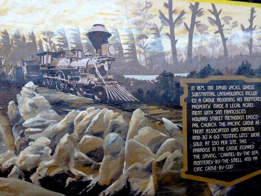

Photo Credits: [1] MULTIROTORCAM, ACCOUNT USER ON VIDMOON [2] AMIGO KANDU [3] AMIGO KANDU [4] AMIGO KANDU [5] AMIGO KANDU
Locationbig map
| Directions Information | Pacific Grove, CA Lovers Point Park, walk north along the paved Bicycle/Jogging path 1/4 mile, view mural on wall along the path. |
|---|---|
| Location Description | Along MONTEREY PENINSULA RECREATION PATH, a very long painted mural showing local people histories. |
| UTM (WGS84 Datum) | 10S E 597182 N 4053559 |
| Decimal Degrees | 36.62261667, -121.91313333 |
| Degrees and Decimal Minutes | N 36° 37.357', W 121° 54.788' |
| Degrees, Minutes and Seconds | 36° 37' 21.4200" N, 121° 54' 47.2800" W |
| Driving Directions | Google Maps |
| Area Code(s) | 831 |
| Can be seen from road? | No |
| Is marker in the median? | No |
| Which side of the road? | Marker is on the right when traveling South |
| Closest Postal Address | At or near 125 Monterey Peninsula Recreational Trail, Pacific Grove CA 93950, US |
| Alternative Maps | Google Maps, MapQuest, Bing Maps, Yahoo Maps, MSR Maps, OpenCycleMap, MyTopo Maps, OpenStreetMap |
Is this marker missing? Are the coordinates wrong? Do you have additional information that you would like to share with us? If so, check in.
Nearby Markersshow on map
Comments 0 comments