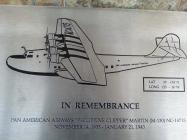
In Remembrance
Pan American Airways "Philippine Clipper" Martin (M-130) NC-14715
November 14, 1935 - January, 21, 1943
History
Total hours in the air 14,628. After eight years of flying the Pacific Ocean and strafed by Japanese aircraft at Wake Island on December 8, 1941 the Philippine Clipper crashed near this site the morning of January 21, 1943 while trying to let down through bad weather. She was enrollee from Pearl Harbor, Oahu, Hawaiian Islands to San Francisco Bay with nine Pan American crew members and ten U.S. Navy passengers. There were no survivors.
PAA
Robert M. Elzey, Captain · Orvan K. Judd, 1st Officer · John R. Maynard, 2nd Officer · George H. Aabel, 3rd Officer, Leo A. MacKota, 1st Engineer · John J. Eagen, Sr., 2nd Engineer · Clarence P. Thompson, 1st Radio Officer · George W. Angus, 2nd Radio Officer · John G. Hill, Steward
Passengers
Robert English Radm, USV, Cmdr, Pacific Submarine Flt. · Captain Robert H. Smith · Captain Robert E. Thomas · Captain Donald C. Godwin · Commander John J. Crane · Commander Francis L. Black · Commander William G. Myers · Lt. Commander John O.R. Coll · Lt. Commander George R. Stone · Lt. Edna O. Morrow, Nurse
Plaque above:
Mr. and Mrs. Lowell Wilcox of Ukiah
| HM Number | HM1QIW |
|---|---|
| Tags | |
| Placed By | Mr. and Mrs, Lowell Wilcox |
| Marker Condition |           10 out of 10 (1 reports) |
| Date Added | Tuesday, January 19th, 2016 at 1:03pm PST -08:00 |
| UTM (WGS84 Datum) | 10S E 565997 N 4151988 |
|---|---|
| Decimal Degrees | 37.51248333, -122.25321667 |
| Degrees and Decimal Minutes | N 37° 30.749', W 122° 15.193' |
| Degrees, Minutes and Seconds | 37° 30' 44.94" N, 122° 15' 11.58" W |
| Driving Directions | Google Maps |
| Area Code(s) | 650, 310, 415, 949, 510 |
| Which side of the road? | Marker is on the right when traveling North |
| Closest Postal Address | At or near 601 Skyway Rd, San Carlos CA 94070, US |
| Alternative Maps | Google Maps, MapQuest, Bing Maps, Yahoo Maps, MSR Maps, OpenCycleMap, MyTopo Maps, OpenStreetMap |
Is this marker missing? Are the coordinates wrong? Do you have additional information that you would like to share with us? If so, check in.
I Saw The Marker
The marker can be seen in front of the Hiller Aviation museum in San Carlos, California.
Not realizing that this website excists I didn't take a picture of the whole marker. By the way the marker is a huge rock. I did however take pictures of all the engraved parts, the crew, the passengers, the airplane and the sponsor.
Jul 24, 2016 at 1:32pm PDT by yscholz
- Is this marker part of a series?
- What historical period does the marker represent?
- What historical place does the marker represent?
- What type of marker is it?
- What class is the marker?
- What style is the marker?
- Does the marker have a number?
- What year was the marker erected?
- This marker could use another picture or two.
- Can this marker be seen from the road?
- Is the marker in the median?

Comments 0 comments