Inscription
On this lot stood the Spanish Corral, a dance hall house of ill repute for over a decade during the Gold Rush. Two legislative acts of 1855, banned gambling and prostitution. Every fourth business in town was a saloon with ladies of the night, and soiled doves. Isaac Cox wrote of Weaverville, "The entire town seemed a red-light district." But by 1860, many prostitutes had been run out of town. The "ladies" at the Spanish Corral wanted out. They hired some packers to take them to Shasta. A running gun battle ensued between the owner of the Spanish Corral and the women and packers down Main Street. Over 60 rounds were fired, but not a single soul was injured. From the three story Chinese Boomerang to the Spanish Corral, Isaac Cox wrote, "What a Hell was there! The dark regions of crime had vomited forth her stores of lewdness, ignorance and avarice; of meanness and society-cankering rapacity; yet, liberty and freedom was there." Some of the most notable women were Charlotte Bush, Medora McGinchy, Madam Marie Legogneur (LaBeau or La Fontaine), China Em and the infamous Julia C. Bulette who rose to fame in Virginia City, Nevada. The respectability of the town was gained by the fires of 1859 and 1863, cleansing the town of its wickedness and debauchery.
Details
| HM Number | HM1T1P |
|---|---|
| Series | This marker is part of the E Clampus Vitus series, and the Native Sons/Daughters of the Golden West series. |
| Tags | |
| Year Placed | 2014 |
| Placed By | Mt. Bally Parlor #87 of the Native Sons of the Golden West, the Hon. Michael B. Regan, (Chapters #62 & #1) and the Trinitarianus Chapter 62 of the Ancient and Honorable Order of E Clampus Vitus |
| Marker Condition | 0 out of 10 (1 reports) |
| Date Added | Thursday, July 14th, 2016 at 1:04pm PDT -07:00 |
Pictures
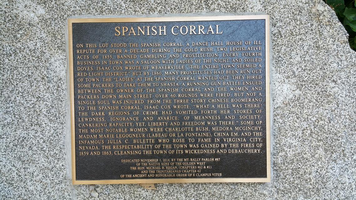
Photo Credits: [1] JSBASHORE
Locationbig map
| UTM (WGS84 Datum) | 10G E 505033 N 5490726 |
|---|---|
| Decimal Degrees | 40.73438333, -122.94039707 |
| Degrees and Decimal Minutes | N 40° 44.063', W 122° 56.4238242' |
| Degrees, Minutes and Seconds | 40° 44' 3.78" N, 122° 56' 25.429452" W |
| Driving Directions | Google Maps |
| Area Code(s) | 530 |
| Which side of the road? | Marker is on the right when traveling North |
| Closest Postal Address | At or near 200-246 Center St, Weaverville CA 96093, US |
| Alternative Maps | Google Maps, MapQuest, Bing Maps, Yahoo Maps, MSR Maps, OpenCycleMap, MyTopo Maps, OpenStreetMap |
Is this marker missing? Are the coordinates wrong? Do you have additional information that you would like to share with us? If so, check in.
Nearby Markersshow on map
Show me all markers in: Weaverville, CA | Trinity County | 96093 | California | United States of America
Maintenance Issues
- What historical period does the marker represent?
- What historical place does the marker represent?
- What type of marker is it?
- What class is the marker?
- What style is the marker?
- Does the marker have a number?
- This marker could use another picture or two.
- Can this marker be seen from the road?
- Is the marker in the median?
Comments 0 comments