Inscription
Hampton National Historic Site
This land was once part of one of the largest estates in Maryland—-and one of the most impressive. The Ridgley family owned Hampton Plantation for more than 200 years, and their home and many farm buildings have changed little since the mid-19th century. This property weathered the growing pains of the nation from colonial times through World War II. Here you can experience American history through the architecture, original objects, and stories of those who lived and worked on this site.Hampton National Historic Site is comprised of two areas, the mansion with is surrounding outbuildings and grounds and the home farm. Explore the park at your own pace. There are parking lots at both areas. You may leave your car at one location and walk the entire site, or drive from area to area.
As their fortunes declined after the Civil War and into the 20th century, the Ridgelys sold nearly all of their empire. The National Park Service now owns and preserves 63 acres of this important core of their estate.
(Inscription beside the map in the lower left) This map represents the Ridgelys' vast holdings in circa 1829. Hampton grew from 1,500 acres, purchased by Col. Charles Ridgely in 1745, to 25,000 acres spread across the region by 1829. It was originally and industrial plantation that served Ridgely's ironworks but evolved into and agricultural estate by the mid-19th century.
Details
| HM Number | HM1XPE |
|---|---|
| Tags | |
| Historical Period | 20th Century, 19th Century, 18th Century |
| Historical Place | Plantation, National Register of Historic Places, Home |
| Marker Type | Historic Building |
| Marker Class | Historical Marker |
| Marker Style | Free Standing |
| Placed By | National Park Service-United States Department of the Interior |
| Marker Condition | No reports yet |
| Date Added | Sunday, April 9th, 2017 at 6:04am PDT -07:00 |
Pictures

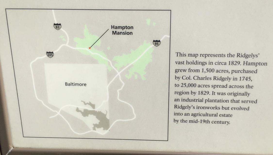
Photo Credits: [1] SEPTEMBERSPARROW1666 [2] SEPTEMBERSPARROW1666
Locationbig map
| UTM (WGS84 Datum) | 18S E 363404 N 4364694 |
|---|---|
| Decimal Degrees | 39.42096639, -76.58687500 |
| Degrees and Decimal Minutes | N 39° 25.258', W 76° 35.2125' |
| Degrees, Minutes and Seconds | 39° 25' 15.4790" N, 76° 35' 12.7500" W |
| Driving Directions | Google Maps |
| Area Code(s) | 410, 443 |
| Can be seen from road? | No |
| Is marker in the median? | No |
| Closest Postal Address | At or near 604 Valley View Rd, Towson MD 21286, US |
| Alternative Maps | Google Maps, MapQuest, Bing Maps, Yahoo Maps, MSR Maps, OpenCycleMap, MyTopo Maps, OpenStreetMap |
Is this marker missing? Are the coordinates wrong? Do you have additional information that you would like to share with us? If so, check in.
Maintenance Issues
- Is this marker part of a series?
- This marker could use another picture or two.
- Which side of the road is the marker located?
Comments 0 comments