Inscription
Pico #4
On this site stands CSO-4 (Pico #4), California's first commerically productive well. It was spudded in early 1876, under the direction of Demetrius G. Scofield, later to become first president of Standard Oil Company of California, and was completed at a depth of 300 feet on September 26, 1876, for an initial flow of 30 barrels of oil a day.Later in the same year, the well was deepened to 600 feet, using what was perhaps the first steam rig employed in oil well drilling in California. Upon this second completion, it produced at a rate of 150 barrels a day, and is still producing after seventy-seven years.
The success of this well prompted formation of the Pacific Coast Oil Company, a predecessor of Standard Oil Company of California, and led to the construction of the state's first refinery nearby. It was not only the discovery well of the Newhall Field, but was, indeed, a powerful stimulus to the subsequent development of the California Petroleum Industry.
Details
| HM Number | HM256T |
|---|---|
| Additional Information | After producing oil for 114 years, Pico #4 shut down in 1990. Half way between Mentryville and Pico #4 is the oil company picnic area Johnson Park, with displays of old drilling equipment. |
| Series | This marker is part of the California State Historical Landmark series |
| Tags | |
| Historical Period | 20th Century, 19th Century |
| Historical Place | Town, Park, Other |
| Marker Type | Historic Object |
| Marker Class | Historical Marker |
| Marker Style | Free Standing |
| Marker Number | 516 |
| Year Placed | 1953 |
| Placed By | Standard Oil Company of California, and Petroleum Production Pioneers Inc |
| Marker Condition |  6 out of 10 (5 reports) |
| Date Added | Friday, February 2nd, 2018 at 1:02pm PST -08:00 |
Pictures
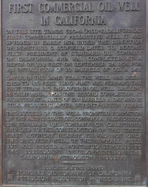
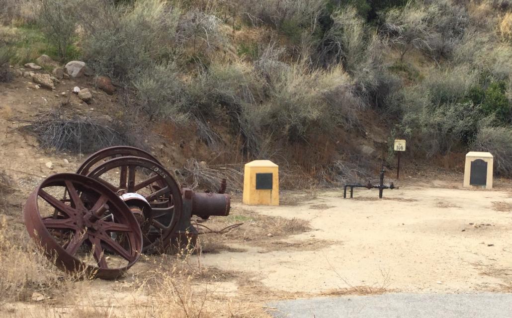
Photo Credits: [1] CRAIG BAKER [2] CRAIG BAKER [3] CRAIG BAKER
Locationbig map
| Directions Information | From Interstate 5, drive west on Pico Cyn Rd to the end, pay to park at historic Mentryville, and walk 1.5 miles up the canyon along the paved trail. Pico #4 is on the right, before the pavement ends. |
|---|---|
| UTM (WGS84 Datum) | 11S E 350184 N 3804419 |
| Decimal Degrees | 34.37031667, -118.62931667 |
| Degrees and Decimal Minutes | N 34° 22.219', W 118° 37.759' |
| Degrees, Minutes and Seconds | 34° 22' 13.1400" N, 118° 37' 45.5400" W |
| Driving Directions | Google Maps |
| Area Code(s) | 661, 818, 626 |
| Can be seen from road? | No |
| Which side of the road? | Marker is on the right when traveling West |
| Closest Postal Address | At or near Pico Canyon Service Rd, Stevenson Ranch CA 91381, US |
| Alternative Maps | Google Maps, MapQuest, Bing Maps, Yahoo Maps, MSR Maps, OpenCycleMap, MyTopo Maps, OpenStreetMap |
Is this marker missing? Are the coordinates wrong? Do you have additional information that you would like to share with us? If so, check in.
Nearby Markersshow on map
Show me all markers in: Stevenson Ranch, CA | Los Angeles County | 91381 | California | United States of America
Maintenance Issues
- Is the marker in the median?
Comments 0 comments