Inscription
In 1875 the Star Oil Company, one of the predecessors of the Standard Oil Company of California, drilled its first Pico Canyon well, which yielded about one hundred barrels per day. The discovery resulted in the erection of the first commercial oil refinery in California the following year.
Details
| HM Number | HMKHR |
|---|---|
| Series | This marker is part of the California Historical Landmark series |
| Tags | |
| Historical Period | 19th Century |
| Historical Place | Other |
| Marker Type | Historic Structure |
| Marker Class | Historical Marker |
| Marker Style | Mounted |
| Marker Number | 172 |
| Placed By | California Department of Public Works - Division of Highways |
| Marker Condition |  9 out of 10 (1 reports) |
| Date Added | Thursday, September 18th, 2014 at 10:59am PDT -07:00 |
Pictures


Photo Credits: [4] CRAIG BAKER [5] CRAIG BAKER
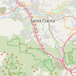
Locationbig map

| Directions Information | To see the refinery, take Pine Ave 0.2 mi south of Newhall Ave and turn left on the dirt road. |
|---|---|
| UTM (WGS84 Datum) | 11S E 356220 N 3805206 |
| Decimal Degrees | 34.37826667, -118.56383333 |
| Degrees and Decimal Minutes | N 34° 22.696', W 118° 33.83' |
| Degrees, Minutes and Seconds | 34° 22' 41.7600" N, 118° 33' 49.8000" W |
| Driving Directions | Google Maps |
| Area Code(s) | 661, 818 |
| Can be seen from road? | No |
| Is marker in the median? | No |
| Which side of the road? | Marker is on the right when traveling East |
| Closest Postal Address | At or near 24518 Lyons Ave, Santa Clarita CA 91321, US |
| Alternative Maps | Google Maps, MapQuest, Bing Maps, Yahoo Maps, MSR Maps, OpenCycleMap, MyTopo Maps, OpenStreetMap |
Is this marker missing? Are the coordinates wrong? Do you have additional information that you would like to share with us? If so, check in.
Nearby Markersshow on map
Show me all markers in: Santa Clarita, CA | Los Angeles County | 91321 | California | United States of America
Comments 0 comments