Inscription
Events Along The Emmitsburg & Waynesboro Turnpike
On June 22, 1863, a skirmish erupted at Monterey Pass when Company D of the 14th Virginia Cavalry attacked portions of Union cavalry under the command of Captain Robert Bell, Captain Samuel Randall, and several members of the Gettysburg Home Guard. The Confederate skirmishers scouted the woods on foot along the Emmitsburg and Waynesboro Turnpike, forcing the militia to retreat toward Fairfield, using Maria Furnace Road, where the chase ended at dusk.On June 28, a skirmish occurred at Fountaindale when a 25 - man detail of Cole's Maryland Cavalry under the command of Lieutenant William Horner, coming from the direction of Monterey Pass, came in contact with a Confederate foraging party under the command of Lieutenant John Chamberlayne, near Jack's Mountain Road. Chamberlayne was gathering supplies and horses when he saw Horner's men and ordered six men with revolvers to charge, while the other 20 unarmed men in the foraging party hurried toward Fairfield with the stolen goods. After being chased by Union soldiers, most of Chamberlayne;s men were captured and taken to Emmitsburg, Maryland.
On June 29, Union General John Buford's Cavalry Division left Middletown, Maryland for Pennsylvania. At Monterey Pass, he observed Confederate troops marching in the distance at Greencastle. After a patriotic welcome by local residents, Buford's cavalry moved toward Fountaindale and bivouacked for a few hours before moving toward Fairfield.
Details
| HM Number | HM5D2 |
|---|---|
| Series | This marker is part of the Pennsylvania: Pennsylvania Civil War Trails series |
| Tags | |
| Historical Period | 19th Century, Civil War |
| Historical Place | Battlefield |
| Marker Type | Other |
| Marker Class | Both |
| Marker Style | Interpretative Marker / Sign |
| Marker Condition | No reports yet |
| Date Added | Friday, September 26th, 2014 at 8:14pm PDT -07:00 |
Pictures
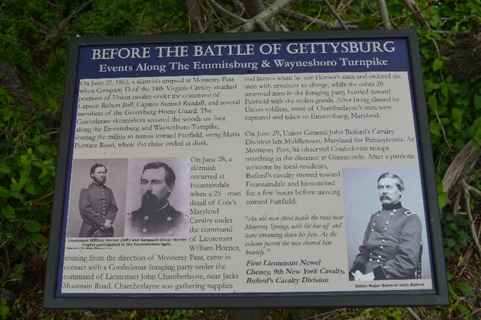
Photo Credits: [1] DOUGLAS MOWEN
Locationbig map
| UTM (WGS84 Datum) | 18S E 289758 N 4402379 |
|---|---|
| Decimal Degrees | 39.74540000, -77.45378333 |
| Degrees and Decimal Minutes | N 39° 44.724', W 77° 27.227' |
| Degrees, Minutes and Seconds | 39° 44' 43.4400" N, 77° 27' 13.6200" W |
| Driving Directions | Google Maps |
| Area Code(s) | 717 |
| Closest Postal Address | At or near 1308-1326 Old Waynesboro Rd, Fairfield PA 17320, US |
| Alternative Maps | Google Maps, MapQuest, Bing Maps, Yahoo Maps, MSR Maps, OpenCycleMap, MyTopo Maps, OpenStreetMap |
Is this marker missing? Are the coordinates wrong? Do you have additional information that you would like to share with us? If so, check in.
Nearby Markersshow on map
Show me all markers in: Fairfield, PA | Adams County | 17320 | Pennsylvania | United States of America
Before The Battle Of Gettysburg
The Battle Of Monterey Pass
The Battle of Monterey Pass (Citizens)
The Battle of Monterey Pass
The Battle of Monterey Pass (Battle Begins)
The Battle of Monterey Pass
The Battle of Monterey Pass (Kirkpatrick)
The Battle of Monterey Pass
Monterey Academy
The Battle of Monterey Pass
Maintenance Issues
- Who or what organization placed the marker?
- This marker could use another picture or two.
- Can this marker be seen from the road?
- Is the marker in the median?
Comments 0 comments