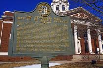
Inscription
Closing in on Atlanta in July, 1864, Maj. Gen. W.T. Sherman found it "too strong to assault and too extensive to invest." To force its evacuation, he sent Maj. Gen. Geo. Stoneman's cavalry [US] to cut the Macon railway by which its defenders were supplied. At the Battle of Sunshine Church (19 miles NE of Macon), Stoneman surrendered with 600 men to Brig. Gen. Alfred Iverson, Jr., [CS], after covering the escape northward of Adams' and Capron's brigades. Both units retreated via Athens, intending to resupply their commands there and to "destroy the armory and other government works," but were stopped at the river bridge south of Athens by Home Guard units with a battery of guns. Unable to cross, they turned west; Capron on the Hog Mountain road through Jug Tavern (Winder), and Adams on roads farther north by which he reached the Union lines near Marietta without further losses.
Capron passed through Jug Tavern late that night and marched to King's Tanyard (5 miles NW on State 211) where he halted for two hours to rest his exhausted command. Before dawn on August 3rd, he was surprised by Williams' Kentucky brigade [CS]. About 430 of his men were captured and sent to Athens, a few escaping through the woods. Capron himself, with six men, reached the Union lines near Marietta four days later — on foot.
This action, known also as the Battle of Jug Tavern, was the final event of the Federal fiasco called the Stoneman Raid.
Details
| HM Number | HMBB8 |
|---|---|
| Series | This marker is part of the Georgia: Georgia Historical Society/Commission series |
| Tags | |
| Marker Number | 007-4 |
| Year Placed | 1957 |
| Placed By | Georgia Historical Commission |
| Marker Condition | No reports yet |
| Date Added | Wednesday, October 15th, 2014 at 10:29am PDT -07:00 |
Pictures
Photo Credits: [1] HANK MYERS
Locationbig map
| UTM (WGS84 Datum) | 17S E 248625 N 3764619 |
|---|---|
| Decimal Degrees | 33.99210000, -83.72140000 |
| Degrees and Decimal Minutes | N 33° 59.526', W 83° 43.284' |
| Degrees, Minutes and Seconds | 33° 59' 31.56" N, 83° 43' 17.04" W |
| Driving Directions | Google Maps |
| Area Code(s) | 770, 678 |
| Closest Postal Address | At or near 33 N Broad St, Winder GA 30680, US |
| Alternative Maps | Google Maps, MapQuest, Bing Maps, Yahoo Maps, MSR Maps, OpenCycleMap, MyTopo Maps, OpenStreetMap |
Is this marker missing? Are the coordinates wrong? Do you have additional information that you would like to share with us? If so, check in.
Nearby Markersshow on map
Maintenance Issues
- What historical period does the marker represent?
- What historical place does the marker represent?
- What type of marker is it?
- What class is the marker?
- What style is the marker?
- This marker could use another picture or two.
- Can this marker be seen from the road?
- Is the marker in the median?

Comments 0 comments