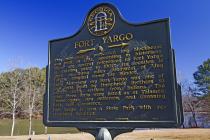
Inscription
<———<<<<
This remarkably preserved log blockhouse was built in 1793, according to historians. There are several references to Fort Yargo as existing prior to 1800. Its location is given as three miles southwest of "Jug Tavern," original name for Winder.Early historians say Fort Yargo was one of four forts built by Humphries Brothers to protect early white settlers from Indians. The other three forts were listed as at Talassee, Thomocoggan, now Jefferson, and Groaning Rock, now Commerce.
Fort Yargo is now a State Park with recreational facilities.
Details
| HM Number | HMESV |
|---|---|
| Series | This marker is part of the Georgia: Georgia Historical Society/Commission series |
| Tags | |
| Marker Number | 007-1 |
| Year Placed | 1954 |
| Placed By | Georgia Historical Commission |
| Marker Condition | No reports yet |
| Date Added | Friday, October 3rd, 2014 at 10:42pm PDT -07:00 |
Pictures
Photo Credits: [1] HANK MYERS
Locationbig map
| UTM (WGS84 Datum) | 17S E 247307 N 3762931 |
|---|---|
| Decimal Degrees | 33.97658333, -83.73516667 |
| Degrees and Decimal Minutes | N 33° 58.595', W 83° 44.11' |
| Degrees, Minutes and Seconds | 33° 58' 35.70" N, 83° 44' 6.60" W |
| Driving Directions | Google Maps |
| Area Code(s) | 770, 678 |
| Closest Postal Address | At or near 8682-8798 Fort Yargo Road, Winder GA 30680, US |
| Alternative Maps | Google Maps, MapQuest, Bing Maps, Yahoo Maps, MSR Maps, OpenCycleMap, MyTopo Maps, OpenStreetMap |
Is this marker missing? Are the coordinates wrong? Do you have additional information that you would like to share with us? If so, check in.
Nearby Markersshow on map
Maintenance Issues
- What historical period does the marker represent?
- What historical place does the marker represent?
- What type of marker is it?
- What class is the marker?
- What style is the marker?
- This marker could use another picture or two.
- Can this marker be seen from the road?
- Is the marker in the median?

Comments 0 comments