Inscription
By the 1890's New Milford's old wooden bridges had outlived their usefulness, considering their age, the increasing amount of traffic and the coming of the horseless carriage. A sturdy and very ornate iron bridge, built by the Berlin Iron Bridge Company, had replaced the covered wooden bridge at Boardman's crossing in 1888, and it's performance and appearance pleased town officials. In early 1895, Granville M. Breinig, President of the Bridgeport Wood Finishing Company approached the town Selectmen with an attractive proposition. Mr, Breinig indicated that his company used the public road that connected with the old wooden bridge in its operation, and profits were severely impacted by restrictions placed on the bridge. His proposal was to exchange the public road for a new road, which would be built on company land eight rods to the south, and given to the town at no cost. In addition, his company would donate $1000 toward the cost of a new iron bridge. The proposal was unanimously accepted at a town meeting on February 23, 1895. The Falls Bridge was completed the same year at a cost of $7,938.
Facts
Originally known as Falls Bridge or Bridge at Great Falls
Size
19 feet wide, 173 feet long and 100 feet above the gorge and rapids.
Lenticular Truss Design
Built by Berlin Iron Bridge Co., Berlin, CT. Over 1000 were built by Berlin Iron Bridge Co. before 1900. One of four of its design still remaining in Connecticut.
Recognition
The National Register of Historic Places in 1976
Historic Highway Bridge designation by CT Department of Transportation
Historic American Engineering Record in Library of Congress
Dedicated June 16, 2007
Details
| HM Number | HMF17 |
|---|---|
| Tags | |
| Year Placed | 2007 |
| Placed By | Friends of Lover's Leap State Park |
| Marker Condition | No reports yet |
| Date Added | Tuesday, October 14th, 2014 at 3:20pm PDT -07:00 |
Pictures

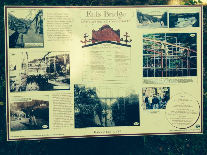
Photo Credits: [1] MATTDS01
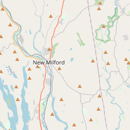
Locationbig map

| UTM (WGS84 Datum) | 18T E 632812 N 4600356 |
|---|---|
| Decimal Degrees | 41.54385000, -73.40766667 |
| Degrees and Decimal Minutes | N 41° 32.631', W 73° 24.46' |
| Degrees, Minutes and Seconds | 41° 32' 37.86" N, 73° 24' 27.60" W |
| Driving Directions | Google Maps |
| Area Code(s) | 860, 203 |
| Closest Postal Address | At or near 51 Pumpkin Hill Rd, New Milford CT 06776, US |
| Alternative Maps | Google Maps, MapQuest, Bing Maps, Yahoo Maps, MSR Maps, OpenCycleMap, MyTopo Maps, OpenStreetMap |
Is this marker missing? Are the coordinates wrong? Do you have additional information that you would like to share with us? If so, check in.
Nearby Markersshow on map
Show me all markers in: New Milford, CT | Litchfield County | 06776 | Connecticut | United States of America
Maintenance Issues
- Is this marker part of a series?
- What historical period does the marker represent?
- What historical place does the marker represent?
- What type of marker is it?
- What class is the marker?
- What style is the marker?
- Does the marker have a number?
- This marker could use another picture or two.
- Can this marker be seen from the road?
- Is the marker in the median?
Comments 0 comments