Inscription
Historic Pottstown Walking Tour
The stone dwelling that originally stood on this ground was built in 1770 by a member of the Potts family. In 1842, Jonas Smith bought it from one of its subsequent owners and opened a store. In 1886, the Security and Iron Banks purchased the property for $27,000 from the estate of the Hartranft Bros. who had become partners in the store in 1847 (Jonas Smith having retired in 1855).Construction of the bank building was begun in mid 1887. Jacob Fegely supervised the project with E.F. Bernard as architect and Davidheiser & Wiand as contractors. A total of 700,000 bricks were used at a cost of $8.00 per thousand. Samuel Buchanan, a relative of President James Buchanan, laid 13,000 yards of plaster. The stone came from Monocacy and all other materials were supplied locally.
Each bank occupied a side of the first floor until 1915 when the Iron Bank moved out. The Security Co. reorganized as The Security Trust and expanded to the entire first floor. Some of the other original occupants included the Post Office, Western Union, Kings' Daughters Meeting Hall, Young Men's Democratic Hall, A.K. Shaner Real Estate, Guildin, Guilden & Snell and Henry D. Saylor, Attorney-at-Law. Later tenants included Jacob Bahr & Sons and Sanders & Thomas. In more recent years, it has been known as the Fidelity Bank Building.
— David R. Kerns
Details
| HM Number | HMFB5 |
|---|---|
| Tags | |
| Year Placed | 2002 |
| Placed By | Greystone Capital Partners and Pottstown 250th Anniversary Committee |
| Marker Condition | No reports yet |
| Date Added | Tuesday, October 21st, 2014 at 11:39pm PDT -07:00 |
Pictures
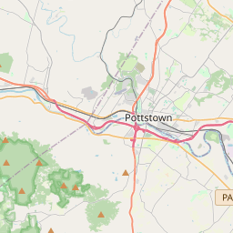
Locationbig map


| UTM (WGS84 Datum) | 18T E 444627 N 4455233 |
|---|---|
| Decimal Degrees | 40.24571667, -75.65103333 |
| Degrees and Decimal Minutes | N 40° 14.743', W 75° 39.062' |
| Degrees, Minutes and Seconds | 40° 14' 44.58" N, 75° 39' 3.72" W |
| Driving Directions | Google Maps |
| Area Code(s) | 484, 610 |
| Closest Postal Address | At or near 138-166 E High St, Pottstown PA 19464, US |
| Alternative Maps | Google Maps, MapQuest, Bing Maps, Yahoo Maps, MSR Maps, OpenCycleMap, MyTopo Maps, OpenStreetMap |
Is this marker missing? Are the coordinates wrong? Do you have additional information that you would like to share with us? If so, check in.
Nearby Markersshow on map
Show me all markers in: Pottstown, PA | Montgomery County | 19464 | Pennsylvania | United States of America
Maintenance Issues
- Is this marker part of a series?
- What historical period does the marker represent?
- What historical place does the marker represent?
- What type of marker is it?
- What class is the marker?
- What style is the marker?
- Does the marker have a number?
- This marker needs at least one picture.
- Can this marker be seen from the road?
- Is the marker in the median?
Comments 0 comments