Inscription
Early Industrial Development in Western Alexandria
The area west of the Mill Race complex once was a sloping meadow through which ran the meandering tail race of the Cameron Mills. The mill site itself was located beneath what is now the parking garage of the Hoffman Center complex. Built in the 1790s, the twin mills at Cameron produced flour, meal, and feed both for local consumption and for export. From the mid-19th century until 1919, the firm of Roberts and Hunt operated the mills, farmed the surrounding property, and maintained a feed and grain store on Alexandria's waterfront. The western mill building was destroyed by fire in 1928.In 1851, the newly founded Alexandria Water Company converted the eastern mill into a pumping station, installing a new iron wheel and a pump inside the building. The pump drew water from the 60-year-old millrace and pumped it into a reservoir at the top of nearby Shuter's Hill. From there, it was distributed through a gravity-fed system to households and businesses throughout Alexandria. The Cameron Pumping Station continued to supply water to the city through the mid-20th century.
(Sidebar):
The Cameron Valley, through which Eisenhower Avenue runs, has served as an industrial and commercial center for Northern Virginia for over 250 years. At one time, Cameron Run and its estuary, Great Hunting Creek, provided direct access to the Potomac River, while surface routes funneled Northern Virginia's products to the stream's head of navigation. The "Road to Richmond" (today's Telegraph Road) and the Little River Turnpike (now Duke Street) were the major land routes into this area. In the mid-19th century, two railroads also acquired rights-of-way through the valley. These networks allowed Northern Virginians to ship their products to Alexandria's wharves, and from there, to markets around the world.
Water from Cameron Run also stimulated commercial and industrial development. A dam on the upper reaches of the stream diverted water through a mile-long millrace; this water supply turned the wheels of several gristmills in the valley, and later even provided water for the city. Today's office and condominium complexes, the Beltway, Metro, and Eisenhower Avenue itself represent the latest chapter in the economic development of the Cameron Valley.
Details
| HM Number | HMI3H |
|---|---|
| Tags | |
| Placed By | The City of Alexandria |
| Marker Condition | No reports yet |
| Date Added | Thursday, September 25th, 2014 at 7:57pm PDT -07:00 |
Pictures
Locationbig map

| UTM (WGS84 Datum) | 18S E 320259 N 4296747 |
|---|---|
| Decimal Degrees | 38.80116667, -77.06985000 |
| Degrees and Decimal Minutes | N 38° 48.07', W 77° 4.191' |
| Degrees, Minutes and Seconds | 38° 48' 4.20" N, 77° 4' 11.46" W |
| Driving Directions | Google Maps |
| Area Code(s) | 202, 703, 571 |
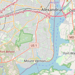
| Closest Postal Address | At or near 2337-2359 Eisenhower Ave, Alexandria VA 22314, US |
| Alternative Maps | Google Maps, MapQuest, Bing Maps, Yahoo Maps, MSR Maps, OpenCycleMap, MyTopo Maps, OpenStreetMap |
Is this marker missing? Are the coordinates wrong? Do you have additional information that you would like to share with us? If so, check in.
Nearby Markersshow on map
Maintenance Issues
- Is this marker part of a series?
- What historical period does the marker represent?
- What historical place does the marker represent?
- What type of marker is it?
- What class is the marker?
- What style is the marker?
- Does the marker have a number?
- What year was the marker erected?
- This marker needs at least one picture.
- Can this marker be seen from the road?
- Is the marker in the median?
Comments 0 comments