Inscription
These fifteen wooded acres were purchased by Joyce and Edgar Anderson in 1950 and permanently preserved through their generosity in partnership with Harding Land Trust, Harding Township and New Jersey Audobon Society. The beauty of the land inspired Anderson's renowned art and their dream to protect land and its wildlife for all future generations.
"As responsible citizens we don't own our land, we are stewards of our land. We hope to pass it on in better shape than we received it." Edgar Anderson
"As responsible citizens we don't own our land, we are stewards of our land. We hope to pass it on in better shape than we received it." Edgar Anderson
Details
| HM Number | HMOMR |
|---|---|
| Additional Information | The land was actually purchased by Joyce & Edgar Anderson in 1951. (Deed: March 14, 1951) |
| Tags | |
| Historical Period | 20th Century |
| Historical Place | Other |
| Marker Type | Historic District |
| Marker Class | Historical Marker |
| Marker Style | Free Standing |
| Year Placed | 2010 |
| Placed By | Harding Land Trust and the New Jersey Audubon Society |
| Marker Condition | No reports yet |
| Date Added | Thursday, September 4th, 2014 at 10:42am PDT -07:00 |
Pictures
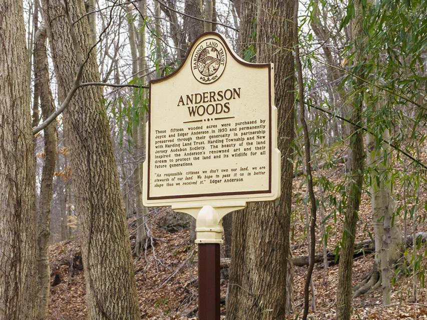
Photo Credits: [1] J. BOAL
Locationbig map
| Directions Information | Tempe Wick Road, Harding Township, New Jersey |
|---|---|
| UTM (WGS84 Datum) | 18T E 539737 N 4511655 |
| Decimal Degrees | 40.75490000, -74.52925000 |
| Degrees and Decimal Minutes | N 40° 45.294', W 74° 31.755' |
| Degrees, Minutes and Seconds | 40° 45' 17.6400" N, 74° 31' 45.3000" W |
| Driving Directions | Google Maps |
| Area Code(s) | 973, 201, 908, 862 |
| Can be seen from road? | Yes |
| Closest Postal Address | At or near 501 County Rd 646, Morristown NJ 07960, US |
| Alternative Maps | Google Maps, MapQuest, Bing Maps, Yahoo Maps, MSR Maps, OpenCycleMap, MyTopo Maps, OpenStreetMap |
Is this marker missing? Are the coordinates wrong? Do you have additional information that you would like to share with us? If so, check in.
Maintenance Issues
- Is this marker part of a series?
- This marker could use another picture or two.
- Is the marker in the median?
Comments 0 comments