Inscription
My Lady's Manor
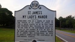
Established 1750 as a Chapel of Ease in the Parish of St. John's of Joppa. In a brick chapel 60 x 30 feet, now the transept, was finished on this site "in the fork of the Gunpowder River" at the cost of 790 pounds. In 1770 by Act of the Maryland Assembly the separate Parish of St. James's was established. In 1950 St. James's completed two centuries of continuous service.Details
| HM Number | HMOR |
|---|---|
| Tags | |
| Historical Period | 18th Century |
| Historical Place | Church/House of Worship, Cemetery |
| Marker Type | Historic Building |
| Marker Class | Historical Marker |
| Marker Style | Free Standing |
| Year Placed | 1955 |
| Placed By | State Roads Commission |
| Marker Condition | No reports yet |
| Date Added | Saturday, September 13th, 2014 at 5:47am PDT -07:00 |
Pictures
Photo Credits: [1] SEPTEMBERSPARROW1666 [2] SEPTEMBERSPARROW1666
Locationbig map
| UTM (WGS84 Datum) | 18S E 365246 N 4380140 |
|---|---|
| Decimal Degrees | 39.56038333, -76.56860000 |
| Degrees and Decimal Minutes | N 39° 33.623', W 76° 34.116' |
| Degrees, Minutes and Seconds | 39° 33' 37.3800" N, 76° 34' 6.9600" W |
| Driving Directions | Google Maps |
| Area Code(s) | 301, 410 |
| Can be seen from road? | Yes |
| Is marker in the median? | No |
| Which side of the road? | Marker is on the right when traveling South |
| Closest Postal Address | At or near 3128 Monkton Rd, Monkton MD 21111, US |
| Alternative Maps | Google Maps, MapQuest, Bing Maps, Yahoo Maps, MSR Maps, OpenCycleMap, MyTopo Maps, OpenStreetMap |
Is this marker missing? Are the coordinates wrong? Do you have additional information that you would like to share with us? If so, check in.
Nearby Markersshow on map
Maintenance Issues
- Is this marker part of a series?
- This marker could use another picture or two.


Comments 0 comments