Inscription
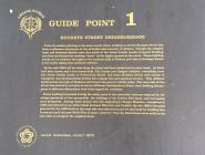
From its earliest platting to the most recent times, building on North Buckeye Street has been a reflective barometer of the attitudes and economy of Abilene. Though the original town and business district were due south of the Union Pacific tracks, frequent flooding and fires accelerated the building "boom" on the higher ground to the north. These building trends are in evidence throughout the northern half of Abilene, yet only on Buckeye Street is the entire eighty year period so obvious.
By the mid-1880's all the land along the street had been deeded and in most cases, lot lines had been drawn and a few homes built. The Kuney and Hodges Addition, extending from the Union Pacific tracks to Fourteenth Street and from Buckeye Street east nearly to Campbell, was systematically divided into regular lots and spacious streets. This addition bordered the east side of Buckeye and formed the pattern visible today. The west side of the street was owned by as many as eleven different individuals or firms, each dividing his property to different dimensions with little regard for roadways.
Home building increased during the early years of the twentieth century inspired by the rising popularity of the automobile, the building of the Golden Belt Road, and increasing local prosperity. Among these homes was the magnificent Seelye Mansion, completed in 1905 and situated on an entire block between Eleventh and Twelfth. By the 1920's the park planned for the 1300 block on the west side was abandoned and the land sold for building lots. It was not until the post World War II years, however, that the final homes were built on the west side to complete the neighborhood.
Details
| HM Number | HMX9H |
|---|---|
| Tags | |
| Marker Number | 1 |
| Year Placed | 1976 |
| Placed By | Abilene Bicentennial Project |
| Marker Condition | No reports yet |
| Date Added | Sunday, September 28th, 2014 at 10:00am PDT -07:00 |
Pictures
Photo Credits: [1] TIM SHEEHAN
Locationbig map
| UTM (WGS84 Datum) | 14S E 654802 N 4310428 |
|---|---|
| Decimal Degrees | 38.92913333, -97.21411667 |
| Degrees and Decimal Minutes | N 38° 55.748', W 97° 12.847' |
| Degrees, Minutes and Seconds | 38° 55' 44.88" N, 97° 12' 50.82" W |
| Driving Directions | Google Maps |
| Area Code(s) | 785 |
| Closest Postal Address | At or near 102 Highland Dr, Abilene KS 67410, US |
| Alternative Maps | Google Maps, MapQuest, Bing Maps, Yahoo Maps, MSR Maps, OpenCycleMap, MyTopo Maps, OpenStreetMap |
Is this marker missing? Are the coordinates wrong? Do you have additional information that you would like to share with us? If so, check in.
Nearby Markersshow on map
Maintenance Issues
- Is this marker part of a series?
- What historical period does the marker represent?
- What historical place does the marker represent?
- What type of marker is it?
- What class is the marker?
- What style is the marker?
- This marker could use another picture or two.
- Can this marker be seen from the road?
- Is the marker in the median?

Comments 0 comments