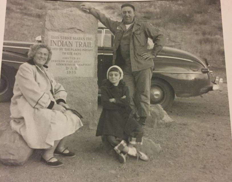
Inscription
This stone marks the Indian Trail used by the Plains Indians to Ute Pass
Details
| HM Number | HMZ3H |
|---|---|
| Series | This marker is part of the Daughters of the American Revolution series |
| Tags | |
| Year Placed | 1935 |
| Placed By | Zebulon Pike and Kinnikinnik Chapters DAR |
| Marker Condition | No reports yet |
| Date Added | Thursday, October 9th, 2014 at 6:03am PDT -07:00 |
Pictures
Locationbig map
| UTM (WGS84 Datum) | 13S E 510545 N 4302449 |
|---|---|
| Decimal Degrees | 38.87083333, -104.87843333 |
| Degrees and Decimal Minutes | N 38° 52.25', W 104° 52.706' |
| Degrees, Minutes and Seconds | 38° 52' 15.00" N, 104° 52' 42.36" W |
| Driving Directions | Google Maps |
| Area Code(s) | 719 |
| Closest Postal Address | At or near 2148-2198 Ute Trail, Colorado Springs CO 80904, US |
| Alternative Maps | Google Maps, MapQuest, Bing Maps, Yahoo Maps, MSR Maps, OpenCycleMap, MyTopo Maps, OpenStreetMap |
Is this marker missing? Are the coordinates wrong? Do you have additional information that you would like to share with us? If so, check in.
Nearby Markersshow on map
Show me all markers in: Colorado Springs, CO | El Paso County | 80904 | Colorado | United States of America
Maintenance Issues
- What historical period does the marker represent?
- What historical place does the marker represent?
- What type of marker is it?
- What class is the marker?
- What style is the marker?
- Does the marker have a number?
- This marker could use another picture or two.
- Can this marker be seen from the road?
- Is the marker in the median?
Comments 0 comments