Inscription
The Industrial Heritage Trail
Fortuitous geography, local engineering ingenuity, and American business acumen were to combine to assure Buffalo a pivotal role in the forwarding of grain to national and international markets. After the opening of the Erie Canal in 1825, transshipment of grain between Great Lakes vesels and other carriers stimulated the city's growth as a major inland port. Storing and handling large volumes of bulk grain required significant innovations in structural engineering and materials handling. Prior to 1842 all transshipmen was manual. In that year Buffalo merchant Joseph Dart built the world's 1st grain transfer elevator. Dart's steam-powered wooden elevator, with innovative "marine leg," established enduring principles of grain handling on the Buffalo waterfront where subsequent evolution refined ther versatility, speed and safety of handling. By 1894, at the time of construction of Buffalo's largest wooden elevator, the Eastern elevator plant was capable of receiving, shipping, storing, mixing, weighing and conditioning grain at considerable rates with many operations being carried out simultaneously. Yet within 5 years, like many of its smaller predecessors, the Eastern was destroyed by fire. The frequent loss of elevators to fire and explosion prompted a search during the 1890s for safer building materials, construction methods, and drive systems. In Buffalo the Great Northern & Electric Elevators pioneered the use of electric drive, and employed novel steel storage bins in pursuit of the "fireproof" elevator. Both steel and tile proved to be transitional materials, soon to be superseded by reinforced concrete bins. Pioneered in Eurpoe in the 1890s, techniques in concrete construction were refined in America after the turn of the century. American innovations in slip-forming construction methods permitted rapid and economic erection of tall cylindrical bins in long interlocking rows. Within 2 years of the construction of the first-slip formed elevator, Buffalo had adopted this construction method; the American Elevator of 1906 displayed a form of industrial architecture that came to characterize the Buffalo waterfront. The construction of Buffalo's 14 waterfront concrete elevator complexes culminated in the provision of 60m bushels peak storage capacity by 1943. By 1924, Buffalo could claim to lead the world in the volume of grain handled; shipments reached over 300,000,000 bushels in 1928, 48% being transferred to rail, 21% to the Welland Canal, 14% to the Bare Canal, while 17% was retained to supply the growing milling trade. However by the 1930s Buffalo's strategic position in th egrain trade bean to falter as U.S. and Csnadian grain began to bypass the port's transfer elevators. Traffic was diverted to Pacific Coast Ports, the improved Welland Canal, the Mississippi River, and the St. Lawrence Seaway. During the 1960s & 1970s many of Buffalo's elevators closed; however as the Nation's largest flour milling center, 17.5m bushels of elevator capacity remains active in this trade. The Buffalo Grain Elevators Recording Project is part of the Historic American Engineering Record (HAER), a long-range program to document historically significant engineering and industrial sites in the U.S. The National Park Service, Department of the Interior administers the HAER program. The Industrial Heritage Committee Inc., Lorraine Oierro, President, and the Historic American Engineering Record, Dr. Robert J. Kapsch, Chief HABS/HAER, co-sponsored the Buffalo Grain Elevators Project, with the co-operation of the Pillsbury Company Mark Norton, plant manaer, Walter Dutka, Snr. Mechanical Engineer, with the assistance of Henry Baxter, Henry Wollenburg, and Jerry Malloy. The field team was under the direction of Eric DeLony, Chief and Principal Architect, HAER, and the project management of Robbyn Jackson, Architect, HAER; and consisted of: Craig Strong, Supervising Architect; Todd Croteau, Christopher Payne, Patricia Reese, architects; Thomas Leary, Supervising Historian; John Healy, and Elizabeth Sholes, historians. Large-format Photography was done by Jet Lowe, HAER photographer. [images] Buffalo, New York. Key: 1 Connecing Termainal Elevator; 2. General Mills Elevator (Frontier, Washburn-Crosby); 3. Kellogg Elevator; 4. Mutual Elevator (Great Northern); 5 Agway Elevator (Wheeler, GLF); Electric Elevator (annex); 7. American Elevator; 8. Standard Elevator (Hecker, Nisbet); 9. Perot Elevator; 10. Lake & Rail Elevator; 11. Marine "A" Elevator; 12. Superior Elevator; 13. Concrete-Central Elevator. Map Source: Port Facilities at Buffalo, N.Y. Board of Engineers for Rivers & Harbors, Washington, DC, 1971 (updated 1990). Movement of Grain 1924. Map source: U.S. Army & Shipping Board, Transportation on the Great Lakes 1926. Loss of Transshipment Trade. A. Pacific Coast; B. Improved Welland Canal 1933; C. Mississippi River 1938; D. St. Lawrence Seaway 1959. Map source: Hammond World AtlasDetails
| HM Number | HM1LR6 |
|---|---|
| Series | This marker is part of the Susquehanna and Tidewater Canal series, and the The Industrial Heritage Trail series. |
| Tags | |
| Historical Period | 19th Century, 20th Century |
| Historical Place | Park |
| Marker Type | Historic Home |
| Marker Class | Historical Marker |
| Marker Style | Commemmorative Marker |
| Year Placed | 2013 |
| Placed By | The Industrial Heritage Committee, Inc. |
| Marker Condition |  10 out of 10 (1 reports) |
| Date Added | Monday, July 13th, 2015 at 6:01am PDT -07:00 |
Pictures
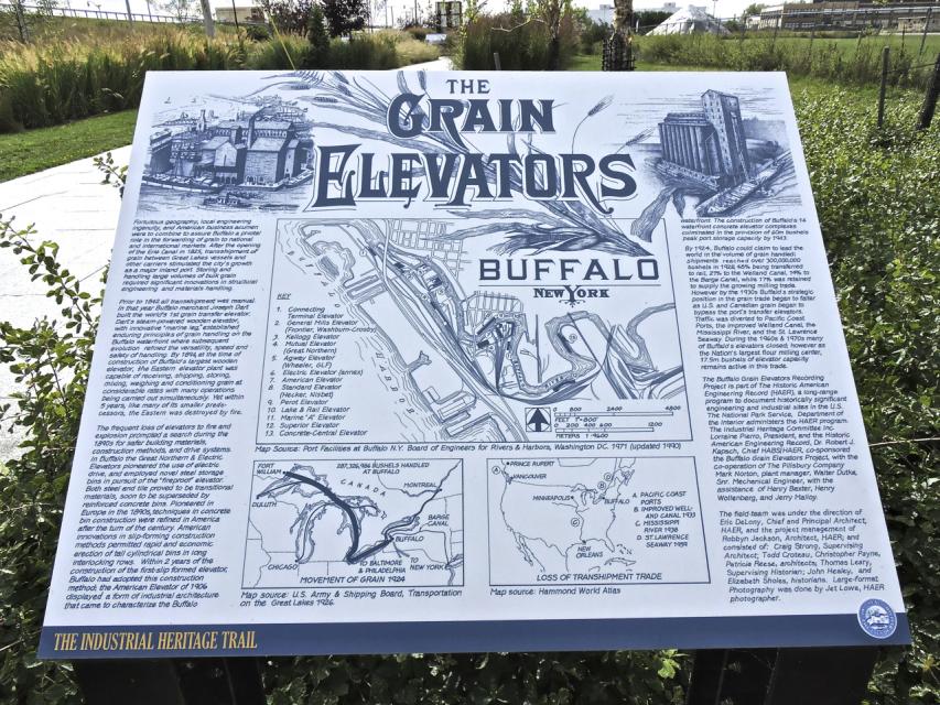
Photo Credits: [1] JERRY M. MALLOY
Locationbig map
| UTM (WGS84 Datum) | 17T E 673962 N 4747336 |
|---|---|
| Decimal Degrees | 42.85881667, -78.87061667 |
| Degrees and Decimal Minutes | N 42° 51.529', W 78° 52.237' |
| Degrees, Minutes and Seconds | 42° 51' 31.7400" N, 78° 52' 14.2200" W |
| Driving Directions | Google Maps |
| Area Code(s) | 716 |
| Can be seen from road? | Yes |
| Is marker in the median? | No |
| Which side of the road? | Marker is on the right when traveling South |
| Closest Postal Address | At or near 813-817 Fuhrmann Boulevard, Buffalo NY 14203, US |
| Alternative Maps | Google Maps, MapQuest, Bing Maps, Yahoo Maps, MSR Maps, OpenCycleMap, MyTopo Maps, OpenStreetMap |
Is this marker missing? Are the coordinates wrong? Do you have additional information that you would like to share with us? If so, check in.
Nearby Markersshow on map
The Engineers of the Grain Elevators
The Grain Industry Decline / Buffalo's Grain Legacy
The First Grain Elevator / Early Grain Elevators
The Early Grain Trade / Influence of the Erie Canal
Fireproof Grain Elevators / Concrete Grain Elevators
The Standard Elevator
The Wheeler / GLF Elevator
The Saskatchewan Pool Elevator
The Spencer Kellogg Elevator
The H-O Oats Elevator
Maintenance Issues
- This marker could use another picture or two.
Comments 0 comments