Inscription
1833
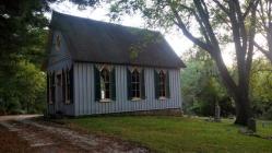
Originally constructed as a log cabin in 1833, St. John's Chapel and land adjacent thereto served the local black community as a house of worship and burying ground. Services had been held in the present chapel since its construction in 1886. The stone parsonage was built around 1833. Declining attendance forced St. John's to close in the early 1960's but in the 1980's the property, still owned by descendants of one of the founders, Aquilla Scott, was restored through involvement of the Ruxton Community.Details
| HM Number | HMUG |
|---|---|
| Tags | |
| Historical Period | 19th Century, 20th Century |
| Historical Place | Church/House of Worship, Cemetery, National Register of Historic Places |
| Marker Type | Historic Building |
| Marker Class | Historical Marker |
| Marker Style | Free Standing |
| Placed By | Friends of St. John's Chapel, Baltimore County Historical Trust and Maryland Historical Society |
| Marker Condition | No reports yet |
| Date Added | Thursday, October 2nd, 2014 at 7:08pm PDT -07:00 |
Pictures
Photo Credits: [1] SEPTEMBERSPARROW1666 [2] SEPTEMBERSPARROW1666 [3] SEPTEMBERSPARROW1666 [4] SEPTEMBERSPARROW1666 [5] SEPTEMBERSPARROW1666 [6] SEPTEMBERSPARROW1666
Locationbig map
| UTM (WGS84 Datum) | 18S E 358435 N 4361882 |
|---|---|
| Decimal Degrees | 39.39483333, -76.64398333 |
| Degrees and Decimal Minutes | N 39° 23.69', W 76° 38.639' |
| Degrees, Minutes and Seconds | 39° 23' 41.4000" N, 76° 38' 38.3400" W |
| Driving Directions | Google Maps |
| Area Code(s) | 301, 410, 443 |
| Can be seen from road? | Yes |
| Is marker in the median? | No |
| Which side of the road? | Marker is on the right when traveling South |
| Closest Postal Address | At or near 7546 MD-134, Towson MD 21204, US |
| Alternative Maps | Google Maps, MapQuest, Bing Maps, Yahoo Maps, MSR Maps, OpenCycleMap, MyTopo Maps, OpenStreetMap |
Is this marker missing? Are the coordinates wrong? Do you have additional information that you would like to share with us? If so, check in.
Nearby Markersshow on map
Maintenance Issues
- Is this marker part of a series?


Comments 0 comments