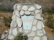
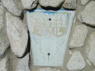
Inscription
On June 1851, the first major group of 520 Mormon settlers entered Southern California at Baldy Mesa Ridge in the West Cajon Pass. This location is northwest of Highway 138, about four miles from the Palmdale Freeway offramp. The Wagon Route ran past this location, along the base of the mountains and into the valley. The pioneers purchased 35,509 acres of land from the Lugo family, and the settlement of San Bernardino was established.
Details
| HM Number | HMYLA |
|---|---|
| Series | This marker is part of the Mormon Pioneer Trail series |
| Tags | |
| Year Placed | 1985 |
| Placed By | Aaron Rogers in association with the San Bernardino County Museum Association |
| Marker Condition |           8 out of 10 (1 reports) |
| Date Added | Friday, September 5th, 2014 at 8:59am PDT -07:00 |
Pictures
Photo Credits: [2] DARREN KERR
Locationbig map
| UTM (WGS84 Datum) | 11S E 457123 N 3795823 |
|---|---|
| Decimal Degrees | 34.30275000, -117.46595000 |
| Degrees and Decimal Minutes | N 34° 18.165', W 117° 27.957' |
| Degrees, Minutes and Seconds | 34° 18' 9.90" N, 117° 27' 57.42" W |
| Driving Directions | Google Maps |
| Area Code(s) | 937 |
| Closest Postal Address | At or near 1517-1529 Pacific Crest Trail, Riverside CA 45431, US |
| Alternative Maps | Google Maps, MapQuest, Bing Maps, Yahoo Maps, MSR Maps, OpenCycleMap, MyTopo Maps, OpenStreetMap |
Is this marker missing? Are the coordinates wrong? Do you have additional information that you would like to share with us? If so, check in.
Nearby Markersshow on map
Comments 3 comments
Maintenance Issues
- What historical period does the marker represent?
- What historical place does the marker represent?
- What type of marker is it?
- What class is the marker?
- What style is the marker?
- Does the marker have a number?
- This marker could use another picture or two.
- Can this marker be seen from the road?
- Is the marker in the median?


Has anyone done any Metal Detecting in any of this area and up the wash? I live in this area and have been wanting
to search this area and where they traveled.
I see a lot of people panning in the area. It's a cool place to explore.im sure there's lots to find.
Has anyone done any Metal Detecting in any of this area and up the wash? I live in this area and have been wanting
to search this area and where they traveled.