Inscription
Original Adobe
Beneath this park rest the stone foundations and floor tiles of the historic adobe where Mexican General Andres Pico and U.S. Lieutenant Colonel John C. Fremont signed the Treaty of Cahuenga on January 13, 1847. Signing the Treaty ended the hostilities in California between the United States and Mexico, and led to the Treaty of Guadalupe-Hidalgo, which ceded California to the U.S. and formally ended the Mexican-American War. The adobe, then owned by a Spaniard, Eulogio de Celis, may have been built as early as 1795 when this land on El Camino Real was occupied by a veteran Mexican soldier, Mariano de la Luz Verdugo. Between 1810 and 1834, the San Fernando Mission owned the land.The adobe also served as a stop on the Butterfield Stage from 1858 to 1861. Butterfield carried passengers, mail, and cargo throughout the western United States from Tipton, MO to San Francisco, CA.
During construction of the Metro Rail station, the MTA team uncovered, researched, evaluated, and cataloged these foundations. In 1997, the archaeological remains of the adobe were determined eligible for listing on the National Register of Historic Places. The remnants have been protected in place for future generations to discover, observe and interpret.
Details
| HM Number | HMYNX |
|---|---|
| Series | This marker is part of the California State Historical Landmark series |
| Tags | |
| Historical Period | 19th Century |
| Historical Place | Park, Other, National Register of Historic Places |
| Marker Type | Historic Building |
| Marker Class | Both |
| Marker Style | Mounted |
| Marker Number | 151 , 29 |
| Placed By | The City of Los Angeles, and the Metropolitan Transit Authority |
| Marker Condition |  10 out of 10 (1 reports) |
| Date Added | Monday, September 8th, 2014 at 10:10am PDT -07:00 |
Pictures
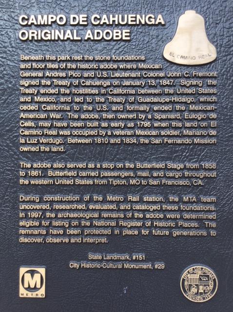


Photo Credits: [1] CRAIG BAKER [2] CRAIG BAKER [4] CRAIG BAKER [5] CB [6] CB [7] CB [8] CB [9] CB [10] CB
Locationbig map
| Directions Information | 3919 Lankershim Blvd, Studio City, CA 91604, one block north of the 101 Freeway. |
|---|---|
| Location Description | Across from Universal Studios, at the Metro Red Line Station. |
| UTM (WGS84 Datum) | 11S E 374390 N 3778478 |
| Decimal Degrees | 34.13965000, -118.36236667 |
| Degrees and Decimal Minutes | N 34° 8.379', W 118° 21.742' |
| Degrees, Minutes and Seconds | 34° 8' 22.7400" N, 118° 21' 44.5200" W |
| Driving Directions | Google Maps |
| Area Code(s) | 818, 323, 310 |
| Can be seen from road? | No |
| Which side of the road? | Marker is on the right when traveling South |
| Closest Postal Address | At or near 3881 Lankershim Blvd, Los Angeles CA 91604, US |
| Alternative Maps | Google Maps, MapQuest, Bing Maps, Yahoo Maps, MSR Maps, OpenCycleMap, MyTopo Maps, OpenStreetMap |
Is this marker missing? Are the coordinates wrong? Do you have additional information that you would like to share with us? If so, check in.
Nearby Markersshow on map
Show me all markers in: Los Angeles, CA | Los Angeles County | 91604 | California | United States of America
Maintenance Issues
- Is the marker in the median?
Comments 0 comments