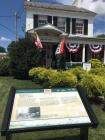
Inscription
Middle of What?
Noted for the tall white spire of the Zion Lutheran Church, Middletown has been framed by its picturesque valley for over two centuries. German Protestants, fleeing persecution in Europe, founded the community before the American Revolution. Michael Jesserong, who laid out the town, named it Middletown as he sold four lots to Conrad Crone in 1768. No one is sure what the name means. Perhaps it refers to the community as the center of its own Middletown Valley, midway between South Mountain and Braddock Heights.That valley, with its rich argriculture, gave the town a ready market from the start. When the National Road came through in the early 1800's, Middletown became a welcome respite between two steep mountain ridges. Harness, blacksmith and carriage shops joined the tavers and hotels that serviced the parade of travelers passing on Main Street. Locals began to refer to their street as "the main road from Baltimore to the western states." The "main road" also brought several Union and Confederate armies during the Civil War. Middletown was ransomed from Confederate General Jubal Early in 1864 for the grand sum of $1,500.
Details
| HM Number | HM26Q |
|---|---|
| Series | This marker is part of the The Historic National Road series |
| Tags | |
| Historical Period | 19th Century |
| Historical Place | Town |
| Marker Type | Historic District |
| Marker Class | Historical Marker |
| Marker Style | Free Standing |
| Placed By | America's Byways and Maryland Heritage |
| Marker Condition | No reports yet |
| Date Added | Wednesday, October 15th, 2014 at 7:59pm PDT -07:00 |
Pictures
Locationbig map
| UTM (WGS84 Datum) | 18S E 280736 N 4369129 |
|---|---|
| Decimal Degrees | 39.44383333, -77.54798333 |
| Degrees and Decimal Minutes | N 39° 26.63', W 77° 32.879' |
| Degrees, Minutes and Seconds | 39° 26' 37.8000" N, 77° 32' 52.7400" W |
| Driving Directions | Google Maps |
| Area Code(s) | 301, 240 |
| Can be seen from road? | Yes |
| Is marker in the median? | No |
| Which side of the road? | Marker is on the right when traveling West |
| Closest Postal Address | At or near 200 W Main St, Middletown MD 21769, US |
| Alternative Maps | Google Maps, MapQuest, Bing Maps, Yahoo Maps, MSR Maps, OpenCycleMap, MyTopo Maps, OpenStreetMap |
Is this marker missing? Are the coordinates wrong? Do you have additional information that you would like to share with us? If so, check in.
Nearby Markersshow on map


Comments 0 comments