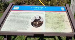
Inscription
Saving the Guns
Gettysburg Campaign When Confederate Gen. J.E.B. Stuart led his cavalry division north across the Potomac River into Maryland in June 1863, about 400 Federals and civilians were captured and then paroled in Brookeville. At the same time, Confederate Gen. Fitzhugh Lee's brigade continued its march north toward Hood's Mill.Near Cooksville, meanwhile, Capt. R.E. Duvall's Co. A, Purnell Legion Md. Cavalry, had bivouacked on the National Road with two ordnance rifles of Capt. W.D. Rank's Battery H, 3rdPa. Artillery. Duvall was escorting the guns to Relay in Baltimore County, where they were to be used in the defense of the Thomas Viaduct on the Baltimore and Ohio Railroad.
When Stuart's advance drove in the Union pickets before dawn on June 29, Duvall sent Sgt. Andrew Duncanand Pvt. Jonathan Norris back to Frederick to warn Gen.George G. Meade of the Confederate presence, then beat a hasty retreat under cover of darkness. He lost some camp equipment and four horses but saved his men and Rank's guns. Near Poplar Springs he encountered Col. John B. Mclntosh's cavalry brigade, which was hunting for Stuart and offered protection. When Duvall's company and the two guns did not reach Relay as expected, area commander Gen.Robert Schenck reported them captured. It was two days before he learned their true status.
Details
| HM Number | HM5ZF |
|---|---|
| Series | This marker is part of the Maryland Civil War Trails series |
| Tags | |
| Historical Period | Civil War |
| Historical Place | Battlefield |
| Marker Type | Other |
| Marker Class | Historical Marker |
| Marker Style | Free Standing |
| Marker Condition | No reports yet |
| Date Added | Tuesday, October 7th, 2014 at 12:01am PDT -07:00 |
Pictures
Photo Credits: [1] SEPTEMBERSPARROW1666 [2] SEPTEMBERSPARROW1666
Locationbig map
| UTM (WGS84 Datum) | 18S E 325897 N 4354347 |
|---|---|
| Decimal Degrees | 39.32103333, -77.01968333 |
| Degrees and Decimal Minutes | N 39° 19.262', W 77° 1.181' |
| Degrees, Minutes and Seconds | 39° 19' 15.7200" N, 77° 1' 10.8600" W |
| Driving Directions | Google Maps |
| Area Code(s) | 410 |
| Can be seen from road? | Yes |
| Is marker in the median? | No |
| Which side of the road? | Marker is on the right when traveling North |
| Closest Postal Address | At or near 14600 Frederick Rd, Cooksville MD 21723, US |
| Alternative Maps | Google Maps, MapQuest, Bing Maps, Yahoo Maps, MSR Maps, OpenCycleMap, MyTopo Maps, OpenStreetMap |
Is this marker missing? Are the coordinates wrong? Do you have additional information that you would like to share with us? If so, check in.
Nearby Markersshow on map
Show me all markers in: Cooksville, MD | Howard County | 21723 | Maryland | United States of America
Related Markers
Maintenance Issues
- Who or what organization placed the marker?
- This marker could use another picture or two.


Comments 0 comments