Inscription
An engineering marvel for early America
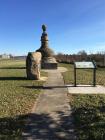
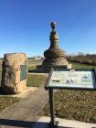
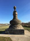
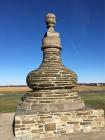
In 1800, travelers expected to ford rivers or use ferries that were slow and often risky in bad weather. The Baltimore and Frederick-Town Turnpike Company, building the first leg of the National Road in 1805, set out to revolutionize American roads. One of the results was an amazing five-arch stone bridge across the Monocacy River.Leonard Harbaugh built the bridge in 1808 for a cost of $55,000. Mr. Harbaugh's signature was a distinctive stone "demijohn" placed on the bridge's east end, giving the span its name the "Jug Bridge." A demijohn was a popular bulbous, thin-necked bottle that often held whiskey. Rumors persist that a real jug of whiskey was planted inside the stone version. The Jug Bridge served faithfully well into the automobile era, but a collapse in 1942 led to a new bridge.
(Sidebar): Marquis de Lafayette
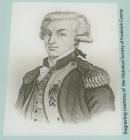
America's hero, Frenchman Marquis de Lafayette, crossed the Jug Bridge in December, 1824, entering Frederick on his triumphal U.S. tour fifty years after the Revolutionary War.
(Captions):
The Jug Bridge as seen in this early 20th century postcard view. The bridge collapsed in 1942, but the toll house on the opposite side of the river, still survives and is now a private residence.
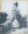
Some horseless carriage adventurers (note the goggles and the duster in the foreground) pose with the stone demijohn at the entrance to the Jug Bridge. The unique monument was moved to its present location in 1965.
Details
| HM Number | HMV3 |
|---|---|
| Series | This marker is part of the The Historic National Road series |
| Tags | |
| Historical Period | Revolutionary, 18th Century |
| Historical Place | Bridge |
| Marker Type | Historic Object |
| Marker Class | Historical Marker |
| Marker Style | Free Standing |
| Placed By | America's Byways |
| Marker Condition | No reports yet |
| Date Added | Tuesday, October 14th, 2014 at 12:52pm PDT -07:00 |
Pictures
Photo Credits: [1] SEPTEMBERSPARROW1666 [2] SEPTEMBERSPARROW1666 [3] SEPTEMBERSPARROW1666 [4] SEPTEMBERSPARROW1666 [5] SEPTEMBERSPARROW1666 [8] ENGRAVING THE COURTESY OF THE HISTORICAL SOCIETY OF FREDERICK COUNTY
Locationbig map
| UTM (WGS84 Datum) | 18S E 294766 N 4364441 |
|---|---|
| Decimal Degrees | 39.40508333, -77.38365000 |
| Degrees and Decimal Minutes | N 39° 24.305', W 77° 23.019' |
| Degrees, Minutes and Seconds | 39° 24' 18.3000" N, 77° 23' 1.1400" W |
| Driving Directions | Google Maps |
| Area Code(s) | 301, 410, 240 |
| Can be seen from road? | No |
| Is marker in the median? | No |
| Closest Postal Address | At or near 1501-6851 E Patrick St, Frederick MD 21701, US |
| Alternative Maps | Google Maps, MapQuest, Bing Maps, Yahoo Maps, MSR Maps, OpenCycleMap, MyTopo Maps, OpenStreetMap |
Is this marker missing? Are the coordinates wrong? Do you have additional information that you would like to share with us? If so, check in.
Nearby Markersshow on map
Show me all markers in: Frederick, MD | Frederick County | 21701 | Maryland | United States of America
Maintenance Issues
- Which side of the road is the marker located?


Comments 0 comments