Inscription
RICE'S POINT
Rice's Point separates Duluth-Superior's outer from it's inner harbor, and is a focal point of Duluth's industrial activity. Many of the city's bridges can be seen, among them the Aerial Lift Bridge to the left, the John A. Blatnik Bridge straight ahead, and the Richard Bong Memorial Bridge to the right. The latter two connect Duluth with Superior, Wisconsin. Since the opening of the first Soo Lock in 1855, joining Lake Superior to the other Great Lakes, Duluth-Superior has been an important shipping center, first for forest products and, with the opening of the Mesabi Range, for iron ore. Duluth-Superior became an international seaport in 1959 with the opening of the St. Lawrence Seaway, of which this is the westernmost terminus - the world's most inland seaport, 2340 miles from the Atlantic Ocean and 602 feet above sea level. Ships from all merchant nations visit the harbor, which ranks above any other inland port in annual tonnage. The port is served by six railroads.
One of a series of Skyline Drive Commemorative Plaques erected in 1972 by the Duluth Lions Club in cooperation with the Duluth Area Chamber of Commerce Convention & Visitors Bureau.
Details
| HM Number | HM2QQ |
|---|---|
| Additional Information | The plaque and the rock slab that it is mounted on both had some graffiti on them in 2015. The small stone pedestal that the marker sits on was in reasonably good shape. |
| Series | This marker is part of the Duluth, Minnesota Skyline Drive Commemorative Plaques series |
| Tags | |
| Historical Period | 19th Century |
| Historical Place | Small Business, River, Other, Business Center, Bridge, Train |
| Marker Type | Historic District |
| Marker Class | Historical Marker |
| Marker Style | Mounted |
| Year Placed | 1972 |
| Placed By | Duluth Lions Club, Duluth Area Chamber of Commerce Convention & Visitors Bureau |
| Marker Condition | No reports yet |
| Date Added | Saturday, September 20th, 2014 at 4:29pm PDT -07:00 |
Pictures
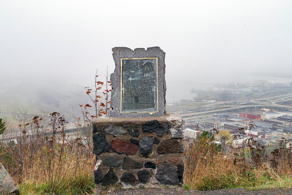
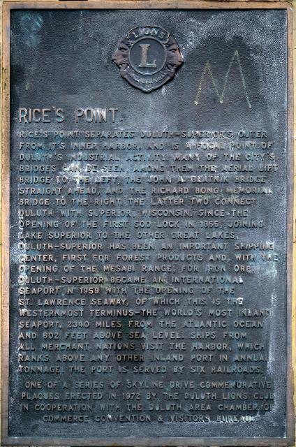
Photo Credits: [1] MARTHA DECKER [2] MARTHA DECKER
Locationbig map
| Location Description | The marker is located in a pullout/scenic overlook down the hill from Enger Tower (one of Duluth's major landmarks) on West Skyline Parkway in Duluth, Minnesota. |
|---|---|
| UTM (WGS84 Datum) | 15T E 566887 N 5180439 |
| Decimal Degrees | 46.77414300, -92.12390300 |
| Degrees and Decimal Minutes | N 46° 46.4486', W 92° 7.4342' |
| Degrees, Minutes and Seconds | 46° 46' 26.9148" N, 92° 7' 26.0508" W |
| Driving Directions | Google Maps |
| Area Code(s) | 218 |
| Can be seen from road? | Yes |
| Is marker in the median? | No |
| Which side of the road? | Marker is on the right when traveling East |
| Closest Postal Address | At or near 1818 W Skyline Pkwy, Duluth MN 55806, US |
| Alternative Maps | Google Maps, MapQuest, Bing Maps, Yahoo Maps, MSR Maps, OpenCycleMap, MyTopo Maps, OpenStreetMap |
Is this marker missing? Are the coordinates wrong? Do you have additional information that you would like to share with us? If so, check in.
Nearby Markersshow on map
Show me all markers in: Duluth, MN | St. Louis County | 55806 | Minnesota | United States of America
Related Markers
Maintenance Issues
- This marker could use another picture or two.
Comments 0 comments