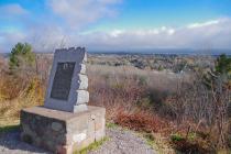
Inscription
Lake Superior
The largest body of fresh water in the world, 380 miles long and 160 miles across. With a maximum depth of 1300 feet, Lake Superior occupies a basin cut 600 million years ago by a receding glacier. The shoreline of the original "Glacial Lake Duluth" was twice as high above sea level as the present lake; portions of this Skyline Parkway follow the lake's former beaches. Lake Superior's 32,483 square miles encompass an area as large as the states of Massachusetts, Connecticut, Vermont and New Hampshire combined. Much of its 2,796 mile coastline, originally inhabited by the Chippewa, has changed little since it was first visited by French voyageurs and the early explorers, among them Dulhut, Groseilliers, and Radisson. The hill at the distant left is Moose Mountain. Below are the communities of Lester Park (left) and Lakeside (right), which became part of Duluth in the 1890s. Across the lake are seen the rolling hills of Wisconsin's South Shore. Minnesota and Wisconsin Points, sand bars protecting Duluth-Superior Harbor, can be seen to the right.
One of a series of Skyline Drive Commemorative Plaques erected in 1972 by the Duluth Lions Club in cooperation with the Duluth Area Chamber of Commerce Convention & Visitors Bureau.
Details
| HM Number | HM2B91 |
|---|---|
| Additional Information | The plaque on the marker is not the original (see photos). Unknown when it was replaced. The marker was in very rough shape in 2015. The Lions Club insignia that should be on the top center of the plaque had been removed. The plaque also had some graffiti and weathered or rubbed off areas of the black background behind the text. The stone slab that it is mounted on and the pedestal that stands on appear to be in reasonably good shape. |
| Series | This marker is part of the Duluth, Minnesota Skyline Drive Commemorative Plaques series |
| Tags | |
| Historical Period | Pre Columbian |
| Historical Place | Other |
| Marker Type | Historic District |
| Marker Class | Historical Marker |
| Marker Style | Mounted |
| Year Placed | 1972 |
| Placed By | Duluth Lions Club, Duluth Area Chamber of Commerce Convention & Visitors Bureau |
| Marker Condition | No reports yet |
| Date Added | Sunday, September 9th, 2018 at 10:16am PDT -07:00 |
Pictures
Photo Credits: [1] MARTHA DECKER [2] MARTHA DECKER [3] MARTHA DECKER [4] MARTHA DECKER
Locationbig map
| Location Description | This marker is located on East Skyline Parkway (AKA Hawk Ridge) overlooking the east end of Duluth, Minnesota and Lake Superior. |
|---|---|
| UTM (WGS84 Datum) | 15T E 573065 N 5187927 |
| Decimal Degrees | 46.84088300, -92.04177000 |
| Degrees and Decimal Minutes | N 46° 50.453', W 92° 2.5062' |
| Degrees, Minutes and Seconds | 46° 50' 27.1788" N, 92° 2' 30.3720" W |
| Driving Directions | Google Maps |
| Area Code(s) | 218 |
| Can be seen from road? | Yes |
| Is marker in the median? | No |
| Which side of the road? | Marker is on the right when traveling East |
| Closest Postal Address | At or near 3920 E Skyline Pkwy, Duluth MN 55804, US |
| Alternative Maps | Google Maps, MapQuest, Bing Maps, Yahoo Maps, MSR Maps, OpenCycleMap, MyTopo Maps, OpenStreetMap |
Is this marker missing? Are the coordinates wrong? Do you have additional information that you would like to share with us? If so, check in.
Nearby Markersshow on map
Show me all markers in: Duluth, MN | St. Louis County | 55804 | Minnesota | United States of America
Related Markers


Comments 0 comments