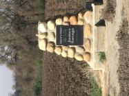
Poole's Ferry

Poole's Ferry (HMJ7H)

Location: Reedley, CA 93654 Fresno County
Buy California State flags at Flagstore.com!
Country: United States of America
Buy United States of America flags at Flagstore.com!

N 36° 35.067', W 119° 27.467'

  • 0 likes
  • 1 check ins
  • 1 favorites
  • 2317 views
Inscription

Smith's Ferry

Side A - North
Poole's Ferry
Most important of Kings River's earliest crossings, it was operated from 1851 - 1857 by William Campbell and John Poole 3 miles above this point. The ferry and its trading post served travelers and miners. In July, 1852, it became the focus of violence when an armed party led by Walter Harvey, Tulare County's first judge, raided a Choinumni Yocuts Indian Village. Yosemite discoverer Major James D. Savage, famed Indian trader and peacemaker, tried to ease tensions but was shot and killed by Harvey in an argument at the trading post on August 16, 1852.

Side B - South
Smith's Ferry
Operated here from 1855 - 1874 by Mr. & Mrs. James Smith, the precursor of Reedley's settlement in 1888. It outlasted other Kings River ferries since Smith's was the only boat that could be approached at high water. His family kept a two story, 11 room hotel on what is now the cemetery's north end where Smith, who died in 1862, rests in the oldest grave. His widow sold the businesses in February 1874. Within months, they closed, victims of the Central Pacific Railroad's construction west of here in 1872. Smith, an early-day assemblyman, is memorialized in the name of a mountain east of here.
Details
HM NumberHMJ7H
Series This marker is part of the E Clampus Vitus series
Tags
Marker Number29
Year Placed1985
Placed ByE Clampus Vitus
Marker Condition
10 out of 10 (1 reports)
Date Added Monday, October 20th, 2014 at 10:40pm PDT -07:00
Pictures
Locationbig map
UTM (WGS84 Datum)11S E 280112 N 4051587
Decimal Degrees36.58445000, -119.45778333
Degrees and Decimal MinutesN 36° 35.067', W 119° 27.467'
Degrees, Minutes and Seconds36° 35' 4.02" N, 119° 27' 28.02" W
Driving DirectionsGoogle Maps
Area Code(s)559
Closest Postal AddressAt or near 1271-1499 S Reed Ave, Reedley CA 93654, US
Alternative Maps Google Maps, MapQuest, Bing Maps, Yahoo Maps, MSR Maps, OpenCycleMap, MyTopo Maps, OpenStreetMap

Is this marker missing? Are the coordinates wrong? Do you have additional information that you would like to share with us? If so, check in.

Check Ins  check in   |    all

I Saw The Marker

On private property but it’s there.

Apr 9, 2018 at 4:55pm PDT by msmithl39144

Comments 0 comments

Maintenance Issues
  1. What historical period does the marker represent?
  2. What historical place does the marker represent?
  3. What type of marker is it?
  4. What class is the marker?
  5. What style is the marker?
  6. This marker could use another picture or two.
  7. Can this marker be seen from the road?
  8. Is the marker in the median?