Inscription
— Gwynns Falls Trail —
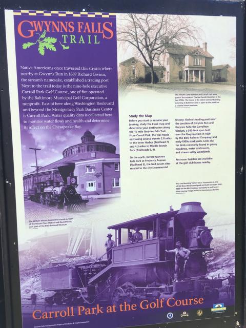
Native Americans once traversed this stream where nearby at Gwynns Run in 1669, Richard Gwinn, the stream's namesake, established a trading post. Next to the trail today is the nine-hole executive Carroll Park Golf Course, one of the five operated by the Baltimore Municipal Golf Corporation, a non-profit. East of here along Washington Boulevard and beyond the Montgomery Park Business Center is Carroll Park. Water quality data is collected here to monitor water flows and health and determine its affect on the Chesapeake Bay.Study the Map.
Before you start or resume your journey, study the kiosk map and determine your destination along the 15-mile Gwynns Falls Trail. From Carroll Park, the trail heads east along several streets, 2.8 miles to the Inner Harbor (Trailhead 7) and 4.3 miles to Middle Branch Park (Trail Heads 8, 9).
To the north, before Gwynns Falls Park at Frederick Avenue (Trailhead 5), the trail passes sites related to the city's commercial history: Gwynns Run and Gwynns Falls; the Carrollton Viaduct, a 300-foot span built over the Gwynns Falls in 1829 by the B&O Railroad Company; and early-1900s stockyards. Look also for birds commonly found in grassy meadows, water catchments, and stream valley woodlands.
Restroom facilities are available at the golf club house nearby.
Photo captions:
[Right upper.] The Mount Clare mansion and Carroll Park were part of the estate of Charles Carroll, Barrister, in the late 1700s. The house is the oldest colonial building surviving in Baltimore and is open to the public as a colonial house museum.
[Left middle.] The William Mason locomotive stands in front of the Mount Clare Station and Roundhouse, now part of the B&O Railroad Museum.
[Right lower.] This coal-burning "camel-back" locomotive is one of 300 Ross Winans designed and built between 1848-1859 for the B&O Railroad Company to pull heavy, slow-moving freight trains on mountainous terrain.
Details
| HM Number | HMRR4 |
|---|---|
| Series | This marker is part of the Maryland: Gwynns Falls Trail series |
| Tags | |
| Historical Period | 20th Century, 19th Century, 18th Century, 17th Century, Colonial |
| Historical Place | Park, Community Center |
| Marker Type | Historic District |
| Marker Class | Historical Marker |
| Marker Style | Free Standing |
| Placed By | The Gwynns Falls Trail Council / A Project of the Parks & People Foundation |
| Marker Condition | No reports yet |
| Date Added | Monday, September 29th, 2014 at 1:52am PDT -07:00 |
Pictures


Locationbig map
| UTM (WGS84 Datum) | 18S E 357831 N 4348222 |
|---|---|
| Decimal Degrees | 39.27170000, -76.64810000 |
| Degrees and Decimal Minutes | N 39° 16.302', W 76° 38.886' |
| Degrees, Minutes and Seconds | 39° 16' 18.1200" N, 76° 38' 53.1600" W |
| Driving Directions | Google Maps |
| Area Code(s) | 410, 301 |
| Can be seen from road? | No |
| Is marker in the median? | No |
| Closest Postal Address | At or near 1520 Washington Blvd, Baltimore MD 21230, US |
| Alternative Maps | Google Maps, MapQuest, Bing Maps, Yahoo Maps, MSR Maps, OpenCycleMap, MyTopo Maps, OpenStreetMap |
Is this marker missing? Are the coordinates wrong? Do you have additional information that you would like to share with us? If so, check in.
Maintenance Issues
- Which side of the road is the marker located?
Comments 0 comments